Southern Forest Watch Loses Legal Fight Against Backcountry Camping Fees

Tuesday, March 31, 2015

No comments
According to documents provided by John Quillen, a lawsuit brought forth by the Southern Forest Watch group that challenged the backcountry camping fee system in Great Smoky Mountains National Park has failed.

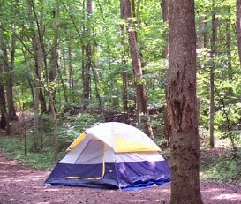
In July of 2011 Great Smoky Mountains National Park officials announced that they were considering a new backcountry fee system to help pay costs associated with backcountry camping. Almost immediately after being announced, the proposal generated strong opposition. Despite the opposition, the park implemented the $4 per night, per person fee in February of 2013. The following month the Southern Forest Watch filed a lawsuit against the fee.

The grass roots group argued that "backcountry camping is differentiated from front country camping in that no amenities are provided to campers other than the metal cables that are constructed to raise campers' gear and food above the level at which bears can access said gear and food". Southern Forest Watch also argued that the backcountry camping fee is illegal under several federal statutes, including the Federal Lands Recreation Enhancement Act and the Administrative Procedures Act.

However, last week, a federal judge in Knoxville ruled that the National Park Service is within its rights to implement the $4 per night per person fee. In the end, the judge stated that the "Plaintiffs do not have standing to challenge the imposition of an online reservation system..."

For more information, please click here or visit the Southern Forest Watch website.


Jeff
HikingintheSmokys.com
HikinginGlacier.com
RockyMountainHikingTrails.com
Grand Teton Trails
Read More

Next Phase of Work on Newfound Gap Road Begins in April

No comments
Great Smoky Mountains National Park officials announced that a project to repave 4.3 miles of Newfound Gap Road will begin on April 13. This work is part of a multi-phased rehabilitation project started in 2007. The section to be resurfaced extends from Sugarlands Visitor Center south to Chimney’s Picnic Area where the last phase ended.

This section of road was last repaved in the 1980s and is badly deteriorated. In addition to the repaving, several drainage culverts will be replaced and two retaining walls will be constructed near the Carlos Campbell Overlook. The contractor will temporarily shift the road to the west by 2 to 3 feet to accommodate a drill rig used for setting the structural parts of the retaining wall near the pullout just north of the main Carlos Campbell Overlook. This lower pullout will be closed for approximately two months while the retaining wall is being constructed, but the main, upper overlook will remain open.

“The scenic drive along Newfound Gap Road is enjoyed by millions of people each year and we are pleased to have this opportunity to improve road conditions,” said Superintendent Cassius Cash. “We have made every effort to minimize the inconvenience to park visitors traveling along the road to reach both park destinations and our gateway communities. The contract includes a variety of work restrictions selected to minimize lane closures during the busiest periods.”

The work will be performed under a $ 14.4 million contract with Estes Brothers Construction of Jonesville, VA and will be administered by the Federal Highway Administration’s Eastern Federal Lands Highway Division. Funding is provided to the NPS through the Federal Lands Transportation Program to support this work.

Motorists should expect delays due to lane closures through June 15. There will not be any daytime lane closures from June 15 through August 15, but nighttime lane closures may occur throughout the project. After August 15, daytime lane closures will again be allowed through September 30. No work of any kind will be permitted on federal holidays or during the month of October. Daytime lane closures will resume from November 1 through December 17.

For the most current road closure information, please follow SmokiesRoadsNPS on Twitter or call 865-436-1200 x 631.


Jeff
HikingintheSmokys.com
HikinginGlacier.com
RockyMountainHikingTrails.com
Grand Teton Trails
Read More

How to Prevent Blisters

Tuesday, March 24, 2015

1 comment
As Sheri Propster emphatically states, blisters do suck! In this short video she offers several ways to help prevent, and treat, blisters. A couple years ago I also published a blog that offers several tips for "taking care of your hiking feet", which provides an overview of taking care of your entire foot while hiking.


Jeff
HikingintheSmokys.com
HikinginGlacier.com
RockyMountainHikingTrails.com
TetonHikingTrails.com
Read More

2015 Spring Ranger-led Program Schedule

Monday, March 23, 2015

No comments
Last week the Great Smoky Mountains National Park published their 2015 Spring Ranger-led Program Schedule. The schedule includes events and guided hikes through May 9th. Hikers may want to note that there area series of three guided hikes, as well as a hiking seminar geared towards beginner hikers. Here's a quick look at some of the programs hikers may be interested in. Each of these occurs on a weekly basis:

Sundays:
So You Wanna Take a Hike?
Sugarlands Visitor Center Patio (1:00 pm)
How should you prepare for day hike or overnight trip in the Smokies? Learn the do’s and don’ts in this fact-filled program for all ages and experience levels.
Duration: 45 min
Difficulty: Easy

Mondays:
Five Sisters Cove: The Walker Sisters of Little Greenbrier (begins April 13th)
Meet at Little Greenbrier School, near Metcalf Bottoms Picnic Area (11:00 a.m.)
Join a ranger for a 2.2 mile roundtrip hike to learn about the famous Walker Sisters of Little Greenbrier. We’ll talk about adaptation and the flexibility required of these strong willed sisters to live in the old-fashioned way.
Duration: 2 ½ hours
Difficulty: Easy to Moderate

Tuesdays:
In the Heart of Greenbrier
Meet at the Porters Creek Trailhead in Greenbrier (1:00 pm)
Enjoy a beautiful walk through an emerald green forest to one of the Smokies’ hidden gems. See a wonderful waterfall, a babbling brook and learn to identify some lovely wildflowers along the way.
Duration: 3 hours
Difficulty: Moderate

Thursdays:
Hike to Andrews Bald (begins April 2nd)
Meet at Forney Ridge Trailhead near the Clingmans Dome Parking Area (11:00 am)
Join a ranger on a 3.6 mile round trip walk through the spruce-fir forest. This moderate hike will take you out to Andrews Bald, a beautiful meadow on a mountaintop. You can hike leisurely back to the parking lot on your own after reaching the bald or return with the ranger. Sturdy footwear, a lunch, and water recommended.
Duration: 3 hours
Difficulty: Moderate

To see the full list of all spring programs, please click here.


Jeff
HikingintheSmokys.com
HikinginGlacier.com
RockyMountainHikingTrails.com
TetonHikingTrails.com
Read More

Appalachian Trail Hiker Killed by Falling Tree

Thursday, March 19, 2015

No comments
On Sunday March 15th, Jason R. Parish, age 36, of Philadelphia, PA, was killed when he sustained a fatal head injury after being struck by a falling tree while hiking on the Appalachian Trail. Parish’s two hiking companions said they began their hike on March 13th from Harpers Ferry, WV. The accident occurred about 6.3 miles north of Harpers Ferry, West Virginia, on a steep and rocky section near the Ed Garvey Shelter in Maryland.

Police received a call notifying them of the incident shortly after 9 a.m. Sunday. An off-duty National Park Service ranger, who happened to be nearby at the time of the incident, performed CPR on Parish until emergency medical personnel arrived at the scene about 10 a.m. Ultimately, life-saving efforts were unsuccessful and a Maryland state medical examiner pronounced Parish dead at the scene. Emergency and safety personnel from Boonsboro, Brunswick, Jefferson, Frederick County, and the Maryland Department of Natural Resources all provided assistance in the response.

"First and foremost our hearts go out to Mr. Parish's family," Appalachian National Scenic Trail Superintendent Wendy Janssen said. "We appreciate the assistance of not only the off-duty National Park Service ranger who responded immediately, but also the emergency medical personnel from our neighboring communities."


Jeff
HikingintheSmokys.com
HikinginGlacier.com
RockyMountainHikingTrails.com
TetonHikingTrails.com
Read More

Smokies Plans Prescribed Burn near Cataloochee

Tuesday, March 17, 2015

No comments
Great Smoky Mountains National Park fire management officials are planning a 550-acre prescribed burn in the Wash Ridge unit adjacent to Cataloochee Valley in North Carolina. Weather permitting, burn operations could begin as early as Wednesday, March 18th, and may continue intermittently through mid-April.

The burn is part of the larger multi-year prescribed fire project where fire managers have been conducting a series of low-intensity, controlled burns to restore the composition and open structure of the oak woodlands that occur on upper slopes and ridges within the area. These fire and drought-tolerant natural communities are important to wildlife and overall ecosystem health which are in decline throughout the Southern Appalachian region.

"One of the goals of the prescribed burn is to improve elk forage and habitat," said Wildland Fire Module Leader Shane Paxton. "This series of burns will reduce the number of fire-sensitive trees and shrubs while increasing the regeneration of oak and yellow pines along with increasing the cover and diversity of native grasses and wildflowers. Over time, this increase in herbaceous vegetation on the forest floor will improve forage for elk which graze the nearby meadows."

The unpaved portion of the Cataloochee Entrance Road beyond the Pretty Hollow Gap Trailhead, locally known as the Wood Creek section, will be closed to vehicles during the burn. However, visitors may park at the Beech Grove School parking area and hike up the road to the trailheads in the upper valley. No trails closures are expected during the burn operations. Visitors should expect to see smoke in the area.

The burn operations will be conducted by park staff and are being funded by the Rocky Mountain Elk Foundation. For more information on the use of prescribed burns in Great Smoky Mountains National Park, visit the park website.


Jeff
HikingintheSmokys.com
HikinginGlacier.com
RockyMountainHikingTrails.com
TetonHikingTrails.com
Read More

Your Chance To Be On Survivorman Episode With Les Stroud

Sunday, March 15, 2015

No comments
Les Stroud, star of OLN Canada and Discovery Channel’s Survivorman, is heading into the wilderness again, but this time he will not be alone. Les is taking one lucky fan with him, with no food, no water, no shelter and no camera crew, for an episode of Survivorman. Les has survived in a raft at sea, fought off the frigid cold, avoided bear attacks and more, logging a half-million miles trekking across the world in the process, but can he survive while having to lookout for another person?

To be considered, fans must convince Stroud, via uploading a five to 10 minute video, that they’re the right person for the job. This is your chance to impress Les! Submit your best video that shows Les your personality, filming ability, and unique qualities. Please note: your video is NOT to be about your survival skills. You have to convince Les that YOU should appear on Survivorman.

Aspiring contestants can visit http://www.lesstroud.ca/survivorman-competition for details about the contest. Submissions will be accepted until 11:59 p.m. ET on Wednesday, April 1st.


Jeff
HikingintheSmokys.com
HikinginGlacier.com
RockyMountainHikingTrails.com
TetonHikingTrails.com
Read More

Volunteers Needed to Staff Clingmans Dome Information Center

Saturday, March 14, 2015

No comments
Great Smoky Mountains National Park is recruiting volunteers to help provide visitor information at Clingmans Dome. The information center sits at 6,300 feet in elevation providing a unique opportunity for park volunteers to assist in educating visitors about high-elevation spruce-fir forests, while also providing recreational, trip planning, and directional information.

The information center, constructed by the Civilian Conservation Corps, originally served as a comfort station, but was converted into a seasonal information center in 2010. The center also includes a bookstore area managed by the Great Smoky Mountains Association (GSMA) offering visitors the opportunity to purchase guides and maps, outdoor apparel, and other GSMA products. Volunteers will work alongside GSMA employees. Each volunteer is asked to work one four-hour shift per week from11:00 a.m. to 3:00 p.m. April 1 through November 30, 2015.

New volunteers must attend two orientation sessions focusing on resource interpretation and working with the public. At each training, guest speakers will share unique biological and historical information to help volunteers learn more about the Clingmans Dome area. The first training session will be held at the Oconaluftee Visitor Center training room near Cherokee, NC on Friday, March 20 from 10:00 a.m. until 2:30 p.m. The second training session will be held at the Sugarlands Center training room near Gatlinburg, TN on Friday, March 27 from 9:30 a.m. until 3:00 p.m. Volunteers must RVSP for training sessions and bring a lunch.

To sign up for this volunteer program or receive more information, please contact Park Resource Education Ranger Florie Takaki by phone at 828-497-1906 or by email.


Jeff
HikingintheSmokys.com
HikinginGlacier.com
RockyMountainHikingTrails.com
TetonHikingTrails.com
Read More

Laurel Falls Trail Temporarily Closed Due to Storm Damage

Thursday, March 12, 2015

No comments
Great Smoky Mountains National Park officials announced the temporary closure of the popular Laurel Falls Trail due to storm damage. The park has received a significant amount of rain over the past week. The rain comes after several ice and snow storms had already saturated the soil. On Wednesday afternoon, a park volunteer discovered a portion of the trail just before the falls had washed out.

“Our trail crews are experienced with these kinds of washouts and will work to make the necessary repairs so that the Laurel Falls Trail, one of our most popular in the park, can be safely reopened for hikers,” said Trails Program Manager Tobias Miller.

Trail crews will assess the condition of the trail and make a plan for repairs. Once those determinations are made, the park will announce an expected reopening date.

For more information on road and trail closures, please visit the park website.


Jeff
HikingintheSmokys.com
HikinginGlacier.com
RockyMountainHikingTrails.com
TetonHikingTrails.com
Read More

All Streams in the Smokies Now Open to Fishing

No comments
Great Smoky Mountains National Park officials announced the reopening of Lynn Camp Prong to fishing effective March 6, 2015 following a seven-year native, brook trout restoration project. The reopening of the 8.5 mile-stream sections marks the first time, since the park’s establishment in 1934, that all streams in the park are open to fishing.

By preserving a healthy, reproducing population of brook trout, the park not only ensures the long-term protection of a unique species, but also the opportunity for future generations to experience and preserve the Southern Appalachian tradition, heritage, and culture associated with brook trout fishing. Southern Appalachian brook trout are the only trout species native to the southern Appalachian Mountains and are genetically unique from brook trout found north of New River, VA. In the southeast, less than 5% of all areas formerly occupied by brook trout prior to European settlement remain. Select park streams provide a unique opportunity to restore, protect, and preserve native brook trout habitat for the entire region.

“The opening of all streams in the park to recreational fishing marks an incredible milestone for the park and speaks to the commitment and dedication of our biologists and partners in restoring fish populations in the Smokies,” said Park Superintendent Cassius Cash.

The park has 2,900 miles of streams, of which an estimated 20% are large enough to support trout populations. Rainbow trout occupy 15.2% of these streams followed by brook trout which are found in 8.6% of the streams and brown trout which are found in 4.6% of the streams. Brook trout lost 75% of their former range in the park after prolific logging in the early 1900s left streams silted and degraded. Throughout the early part of the 20th century, non-native rainbow and brown trout were introduced to park streams to provide fishing opportunities. These trout quickly out-competed and displaced native brook trout throughout many park streams.In the last 30 years, acid rain has further reduced trout populations at elevations above 3,000 feet due to low stream pH. Since 1986, park biologists have restored brook trout to 27.1 miles of 11 different streams in the park greatly expanding their range. These restoration efforts were made possible with support from hundreds of local volunteers and including volunteer groups such as Trout Unlimited, Federation of Fly Fishers, Friends of the Smokies, and local universities.

Using data from long-term monitoring and a recent study, fisheries biologists have determined that recreational fishing under current park regulations has no population level effect on brook trout populations. In addition to fish restoration projects, park biologists are also working hard to improve water quality across park streams. Continued efforts to improve water quality and restore native fish populations will expand habitat for all fish species and these fish-bearing streams will provide a unique mountain fishing experience for visitors of all ages well into the future. For more information about the fisheries program in the park, please visit the park website.

Current park fishing regulations include a 7-inch size limit, 5 fish possession limit and the use of single hook, artificial lures only. For more information about fishing regulations, please visit click here.


Jeff
HikingintheSmokys.com
HikinginGlacier.com
RockyMountainHikingTrails.com
TetonHikingTrails.com
Read More

Decline of the Balds

Friday, March 6, 2015

No comments
The following is a guest blog by Cabins USA Gatlinburg:

"As it stands, the best pasturage is high up in the mountains, where there are "balds" covered with succulent wild grass."

In Our Southern Highlanders, Horace Kephart recalled the prominent grassy balds that were used by settlers in the Smoky Mountains as grazing pasture. Around the time Kephart was exploring the Smokies in the early 1900s, much of the Tennessee-North Carolina border was a large field straddling the high ridge.

This open field stretched for nearly 24 miles, from Silers Bald to Gregory Bald, in Kephart's day. Modern-day hikers can explore this area by hiking along the Appalachian Trail. This route traces the ridge that was once home to grazing pasture and spectacular views as far as the eye can see.

By visiting high elevation fields like Andrews Bald, Spence Field, and Gregory Bald, hikers can still glimpse some of the views that Kephart enjoyed over 100 years ago. However, much of the high ridge in the Smokies has begun to return to the forest with the absence of sheep and cattle.

But how did these balds form? Most of this massive field was the result of work from human hands who cut and burned forest for their livestock. But some balds have more mysterious origins. Theories on Appalachian bald formation range from glacial activity, to grazing by large prehistoric mammals, but no one can say for sure.

A somewhat controversial policy of the park service has been to let nature reclaim the "unnatural" balds that were manmade. Today, the once jaw-dropping views in places like Spence Field, Silers Bald, and Russell Field are steadily being swallowed by brush.

Fortunately, the park service continues to preserve the balds on peaks like Gregory Bald and Andrews Bald. Evidence suggests that these two fields are natural balds that existed before European settlement, so the national park has chosen to keep the forests at bay. Without cutting back the brush, these highland fields and their unique flora would disappear in a few decades.

While we may someday say goodbye to stunning views from Spence Field and Maddron Bald, that day thankfully hasn't come just yet. Until then, we can keep on hiking to these unique and incredible features in the Great Smoky Mountains National Park.


Jeff
HikingintheSmokys.com
HikinginGlacier.com
RockyMountainHikingTrails.com
TetonHikingTrails.com
Read More

The Great Smoky Mountains Scavenger Hunt

Wednesday, March 4, 2015

No comments
Now's the time to gather your friends, family and co-workers together to create a team for the annual Great Smoky Mountains Scavenger Hunt! This year's event will take place on the weekend of March 20th and 21st.

The hunt, organized by the Great Smoky Mountains Institute at Tremont, ranges over most of the park, and uses roads and official trails to access particular areas. Some questions require research to answer. As it is illegal to remove items from the park, one digital camera with a flash memory card will be required per team. Questions are awarded point values based on level of difficulty. The team with the most points may get prizes, but everybody wins!

You can have as many people on your team as you like, provided all fit safely into one vehicle. The event will take place over a 25-hour period with teams receiving their hunt questions via e-mail by 3:30 p.m. on Friday, March 20th and are due back at Tremont no later than 4:30 p.m. on Saturday, March 21st with your answers. A light dinner will be served while tallying takes place. This event is limited to 200 participants so register early!

The cost per team is $50 if registered by Thursday, March 19, 2015 at 4 p.m. Afterwards the cost becomes $60. For more information, please click here.


Jeff
HikingintheSmokys.com
HikinginGlacier.com
RockyMountainHikingTrails.com
TetonHikingTrails.com
Read More

Big South Fork Estimates 80% of Park Impacted by Ice Storm

Tuesday, March 3, 2015

No comments
A large ice storm incident on February 21, 2015, crippled a large portion of the Upper Cumberland Plateau, including the Big South Fork National River and Recreation Area, after a week of snow and subfreezing temperatures. Snow-covered roads became ice sheets. Trees, branches and power lines were broken by the weight of ice and wind gusts of 20 to 30 mph.

A week long assessment has determined that approximately 80 percent of Big South Fork's 125,000 acre total has been affected by the ice storm. Storm related impacts within Big South Fork are primarily located south of the Kentucky state line. Downed timber of enormous magnitude, twisted and stacked upon each other, will require removal from roads and trails in order to allow access. Over 70 miles of park roads and more than 370 miles of trails are impacted. Staff are currently working to open park roads and will have to wait for a spring melt before addressing the damaged trails.

Leatherwood Road has been cleared and is open for normal traffic through the park and the Bandy Creek Visitor Center is accessible and is open for regular hours. For more information on the park, please call (423) 569-9778.


Jeff
HikingintheSmokys.com
HikinginGlacier.com
RockyMountainHikingTrails.com
TetonHikingTrails.com
Read More

"Get On the Trail" Hiking Series

No comments
Join Friends of the Smokies and fitness expert Missy Kane once again for another series of hikes this upcoming spring. Each Wednesday throughout the month of April, Missy and Friends will hike a different trail in the Great Smoky Mountains.

Ms. Kane was an Olympic runner and a Pan American Games medalist.

"Get on the Trail" is a great opportunity for people who are new to the area, or are new to hiking, as well as people who just want to know more about the Park.

The dates for this year's spring series are: April 1st, 8th, 15th, 22nd, and 30th:

APRIL 1st
Twin Creeks Trail to Bud Ogle Cabin
Easy, 4 miles

APRIL 8th
Little Brier Gap Trail to Little Greenbrier Trail
Easy, 4-5 mile loop

APRIL 15th
Porters Creek Trail
Moderate, 7 miles

APRIL 22nd
Appalachian Trail to Sweat Heifer, to Kephart Prong Trail
Moderate, 7.4 miles

APRIL 30th
Big Creek Trail to Campsite #37
Moderate to Difficult, 10.2 miles

The cost is $20.00 per hike, with maps and goodies being provided by Friends and Missy. You must register by calling 865-541-4500 (Covenant Call Center) as space is limited.

Now celebrating it's 17th year, Get on the Trail with Friends and Missy has raised more than $140,000, with proceeds going towards the support for the preservation and protection of Great Smoky Mountains National Park.

For more information, contact Sarah Weeks at Friends of the Smokies, 1-865-932-4794 or sarah@friendsofthesmokies.org.


Jeff
HikingintheSmokys.com
HikinginGlacier.com
RockyMountainHikingTrails.com
TetonHikingTrails.com
Read More

Fontana Dam To Be Designated as Newest Appalachian Trail Community

No comments
The Appalachian Trail Conservancy (ATC), along with the Smoky Mountains Hiking Club (SMHC), invite the public to attend the official designation of Fontana Dam, North Carolina, as the newest Appalachian Trail Community™. The ceremony will be held on Thursday, March 26, and is free and open to the public.

The event will kick off at 11 a.m. with music from the Larry Barnett Duo, allowing attendees to meet and greet each other before the designation ceremony at noon. Following the ceremony, guests are welcome to visit the Mountview Restaurant on the property of the Fontana Village Resort for lunch. A short guided hike beginning at 2:30 p.m. will conclude the day’s festivities.

“The Appalachian Trail Conservancy is proud to celebrate Fontana Dam as an A.T. Community partner in North Carolina that is helping to protect and promote the Appalachian Trail,” said Julie Judkins, community program manager for the ATC. “These new partnerships increase local stewardship of public lands, support community initiatives for sustainable economic development and conservation planning and support healthy lifestyles for community citizens.”

Honored guests and speakers at this event include Wendy Janssen, superintendent of the Appalachian National Scenic Trail; Ron Tipton, executive director of the ATC; Mayor Houston, Fontana Dam; Supervisor Kristin Bail, National Forests of North Carolina; Chair Sara Locke, Town Council; staff from U.S. Senator Burr’s office; staff from Congressman Meadows office, 11th District; Christine Hoyer, Great Smoky Mountains National Park; Marshall McClung, local historian and author; and Regional Director Morgan Sommerville of the ATC’s Southern Office.

“The Town of Fontana Dam is delighted to enter into this partnership with the Appalachian Trail Conservancy to promote the use and appreciation of the Appalachian Trail in our area,” said Councilwoman Sara Locke.

Fontana Dam marks the point where the Appalachian Trail enters Great Smoky Mountains National Park from the south.

Event Overview:
Location: Fontana Village Events Hall, 300 Woods Road, Fontana Dam, NC
Date: Thursday, March 26
11 a.m. Meet and greet and enjoy music from the Larry Barnett Duo
Noon Designation ceremony
1:00 p.m. Music from the Larry Barnett Duo
2:30 p.m. Short guided hike

The Appalachian Trail Community™ program was created by the ATC to recognize communities that promote and care for the Appalachian Trail (A.T.). Working with a growing network of trailside community partners, the program supports communities that play a role in advocating the A.T. as a significant local and national asset and as an international icon. The program assists communities by generating awareness and stimulating outdoor recreation while preserving and protecting the A.T. For more information about the A.T. Community™ program, visit www.appalachiantrail.org/atcommunity.


Jeff
HikingintheSmokys.com
HikinginGlacier.com
RockyMountainHikingTrails.com
TetonHikingTrails.com
Read More