hike
Showing posts with label hike. Show all posts

Mt. Rogers: The Highest Point in Virginia

Sunday, September 9, 2012

1 comment
As many of you are already aware, I absolutely love hiking the balds in the Southern Appalachians. Gregory, Andrews and Rocky Top are some of my favorite destinations in the Smokies. Roan Mountain, Max Patch and the Art Loeb Trail are also notable destinations. However, my absolute favorite hike in the Southern Appalachians is along the Appalachian Trail to the summit of Mt. Rogers in southwestern Virginia.

Nearly the entire length of the four-mile (one-way) hike passes through open country, offering sweeping views of the surrounding wilderness as far as the eye can see. With many rocky outcroppings and sweeping panoramic views, at times it feels more like hiking out west rather than the Appalachian Mountains.

The summit of Mount Rogers also happens to be the highest point in Virginia. While a handful of peaks in the Appalachians are higher, Mount Rogers lays claim to being the highest state highpoint, east of South Dakota, that doesn’t have a road to its summit.

My wife and I had the pleasure of hiking to Mt. Rogers on two recent occasions. Both times we started our hike from Massie Gap in Grayson Highlands State Park, which borders the Mount Rogers National Recreation Area in Jefferson National Forest.

To reach the summit from Massie Gap (elevation 4650 feet) we took the Rhododendron Trail. At first the trail leads across a field and then follows an old wagon road over a hillside. On both of our hikes it was in this area that we first began to see some of the wild ponies for which this area is famous for. In addition to mechanical clearing with chainsaws, grazing cattle, and use of carefully controlled fires, the US Forest Service uses the ponies to help keep the popular balds open.

After about a half-mile we turned onto the Appalachian Trail, which led us up the rugged, rocky outcrops of Wilburn Ridge before passing through Rhododendron Gap. From Rhododendron Gap, it's an easy 1.5-mile hike to the short spur trail to the summit, located just past the Thomas Knob Shelter. This section of trail is just spectacular. The best views and the most beautiful scenery are located along this section of the hike.

Upon turning onto the half-mile spur trail that leads to the summit, we finally reached the tree-line. Unlike most mountains, the forest in this area of the highlands still claims the highest elevations. The 5729-foot summit of Mount Rogers is covered by a thick spruce-fir forest, which means that you won’t have any views at the summit, and is the only place on the entire route where you'll walk amongst trees.

The first time we visited the Mount Rogers area we stayed in Abingdon, about 32 miles west of the park. For anyone who likes history, this is great place to spend a day or two. I also highly recommend having dinner at The Tavern. Built in 1779, it’s the oldest building in town and has played host to notable guests such as Andrew Jackson and King Louis-Phillipe of France.

The following year we stayed in Damascus, which is a little closer to the park. Traversed by the Appalachian Trail, the Virginia Creeper Trail, the Trans-America National Bicycle Trail, the Iron Mountain Trail, and others, Damascus is known appropriately as Trail Town, USA. Additionally, the town holds a big festival each May, known as Trail Days. It attracts over 15,000 people - mostly hikers - in just one weekend. That number is quite remarkable when you consider that there are only about 1000 people that actually live in the town.


Mt. Rogers
(via Massie Gap in Grayson Highlands SP)
RT Hike: 8 Miles
Elev Gain: 1079 Feet
Highest Point: 5729 feet


Jeff
HikingintheSmokys.com

Read More

The GSMA Hike of the Month: Andrews Bald

Tuesday, May 1, 2012

1 comment
Join the Great Smoky Mountains Association for a guided hike to Andrews Bald on Saturday, May 26th.

The highlight of the hike will be an exposure to the first trail that benefited from the "Trails Forever" trail improvement program. Prior to the program the beginning of the trail was extremely rocky. It is now much easier to navigate due to all the hard work of "Trails Forever" National Park Ranger Christine Hoyer and her many volunteers.

The GSMA also hopes to see the Catawba Rhododendrons in bloom on the Bald. It may be a little early, but everything else has been early this year due to the unusually warm winter. Also, from the Bald there are great views of the mountains all the way to Fontana Lake.

If interested, meet at the Clingmans Dome parking lot at 9 am. The hike will be led by Marti Smith, an experienced hiker in the Smokies and 900-miler. It's a 3.8-mile round trip, and considered easy to moderate. Also bring a snack or lunch and water. Dress in layers and bring rain gear, just in case.

The fee is $5 for GSMA members and $10 for non-members. Children 12 and under are free, but must be accompanied by an adult. Call 865-436-7318, ext. 222 or 254 for reservations.


Jeff
HikingintheSmokys.com
Read More

Hike the Wallhalla Trail at Cataloochee Ranch

Thursday, January 26, 2012

1 comment
Get a great start on 2012 by joining the Cataloochee Ranch and the Southern Appalachian Highlands Conservancy for hike near the Cataloochee Ranch. The historic ranch is located on the edge of the Great Smoky Mountains National Park in Maggie Valley where SAHC holds over 300 acres in a conservation easement. Participants will be hiking the Wallhalla Trail, a 4-mile trail that features great views of the Balsam Range and the Campbell Creek basin, rhododendron tunnels, and cove hardwood forests. You'll also get to see the “Sliding Rock,” and towards the end of the hike, will be rewarded with vistas of Maggie Valley and the mountains beyond.

The hike is scheduled for Saturday, February 4th, at 10:30 a.m. The trail is rated as a moderate hike. You'll need to bring water, comfortable shoes, warm clothes and a camera.

The hike is free for members and $10 for non-members. Well behaved dogs are welcome.

You can direct any questions to Rich Preyer, rich@appalachian.org or 828-253-0095 ex. 205.


Jeff
HikingintheSmokys.com
Read More

Andrews Bald Hike with the GSMA

Thursday, September 29, 2011

No comments
Fantastic views and gorgeous fall colors await those hiking to Andrews Bald!

Join the Great Smoky Mountains Association and naturalist Liz Domingue on Saturday, October 8th for a 3.6 mile round-trip hike to Andrews Bald, one of the park's most picturesque destinations. This trail was one of the first to be improved in the park under the Trails Forever program.

Plan on packing a light lunch to enjoy at the bald while taking in the breathtaking colors of Autumn in the vast panorama.

As always, wear good hiking boots (the trail is rocky with a steep downhill section), bring water and rain gear. Though considered an easy hike, a hiking stick might be advisable also to help steady yourself as you traverse the rocks.

Meet Liz at the Clingmans Dome parking lot at 9:00 a.m. for what should prove to be a true Smokies experience!

Reservations are required and limited to 20 participants. A fee of $10 per adult will cover the cost of the presenter. Children under 12 are free. Call 865-436-7318, Ext. 222 or 254 to register.

For more detailed information on the hike to Andrews Bald, please click here.


Jeff
HikingintheSmokys.com
Read More

Hike to Upper Catawba Falls with the Swannanoa Valley Museum

Thursday, March 3, 2011

No comments
This Saturday the Swannanoa Rim Explorer series continues with a hike to Upper Catawba Falls.

The Swannanoa Rim Explorer hiking series is an exclusive program of the Swannanoa Valley Museum, and offers several hikes throught 2011. Each hike will cover a portion of the approximately 31 miles of the Swannanoa Rim, which runs from Jesse’s High Top, across Lakey Gap, over Ridgecrest and Montreat, up to the Blue Ridge Parkway, and down to Cedar Cliff above Camp Rockmont. These hikes will be led by experienced hikers who are also extremely knowledgeable about the history, topography, and ownership of the land.

This is a strenuous hike with a stream crossing - be prepared to wade. (Bring waterproof boots or grocery bags and rubber bands to cover your shoes!) Wear wool socks and bring an extra pair to change into afterward. Hiking poles are also helpful.

From the Trip Leader: The hike is mostly level with a few up & downs and a steep downhill to the bottom of the upper falls. The trail is not a good open one and will include a few scrambles through brush, up & under logs, etc. The main thing one must understand is that there are numerous stream crossings. There are practically no safe rock hops & you should be prepared for wet feet. As you may know wool socks will keep your feet warm enough even when wet, so wear wool and look forward to wading the creek--which at most will be 5-6 inches deep. Bring a dry pair of socks for the hike's end. The out & back trip is probably 6 +/ - miles.

For those interested, meet at 9 AM at the Black Mountain Savings Bank. Hikers will then carpool to Fortune Fields in High Rock Acres for the hike. Bring a bag lunch to eat on site. Cost is $10 for members and $20 for nonmembers. Reservations are required. Call 828-669-9566 or email info@swannanoavalleymuseum.org for more information or to register.


Jeff
HikingintheSmokys.com
Read More

Hike to Looking Glass Rock

Thursday, February 17, 2011

No comments
The Asheville Hiking Meetup Group will be hosting a free hike to Looking Glass Rock in the Pisgah National Forest this Saturday, February 19th.

The hike will be 6.4 miles roundtrip on the out and back trail. Expect to go at a leisurely pace and sticking with the group. It's a moderate/strenuous trail that climbs 1700 feet in 3.2 miles. From its peak are panoramic views of the surrounding Blue Ridge Mountains.

For those interested, meet at 10 a.m. at the Ingles at 301 Long Shoals Road in Arden to carpool to the trailhead.

For more information, e-mail ashevillehikinggroup@gmail.com.


Jeff
HikingintheSmokys.com
Read More

Johnson Farm organizes day hike to Panthertown

Sunday, October 24, 2010

No comments
Historic Johnson Farm is teaming up with Gary Eblen of Diamond Brand Outdoors early next month for a hike in Panthertown.

Nicknamed 'the Yosemite of the East,' Panthertown Valley is home to sheer granite cliffs and domes, cascading waterfalls, valley floors, and rare high altitude bogs.

Interested participants should meet at the Pisgah Forest Ranger Station on Rte 276 in Brevard at 9 a.m. on November 6th.

Organizers ask that you wear comfortable shoes and dress appropriately for the weather. Bring water and a lunch. A map, compass and trail snacks will be provided. The 4-6 mile hike is moderately difficult and is appropriate for those over 16. No pets are permitted.

Since the guided hike is limited to only 10 people, please make your reservation by calling Historic Johnson Farm at 828-891-6585 before November 2nd. The cost is $25 per hiker.

Contact Gary Eblen at geblen@outdoorbrand.com if you would like to borrow a day pack or trekking poles.


Jeff
HikingintheSmokys.com
Read More

In a Quandary

Saturday, October 2, 2010

No comments
The main hiking objective of our recent trip out west was to summit Quandary Peak in central Colorado. At 14,265 feet, Quandary is the 13th highest peak in Colorado, and the highest mountain in the Tenmile Range.

According to 14ers.com the peak’s name comes from a group of miners who were unable to identify a mineral sample found on its slopes in the 1860s. The group was in a quandary over the exact nature of the mineral, and ended up naming the mountain from which it came, “Quandary Peak.”

Arriving at the trailhead near Hoosier Pass that morning, the temperature gauge read a chilly 36 degrees. After a long and very hot summer, this was a bit of a shock to the system.

Although it’s a relatively short hike, and has less elevation gain when compared to other Fourteeners, the trail still packs a punch. Much of the climbing occurs in two relatively short sections. One climbs 1300 feet over a 0.9-mile section roughly midway through the hike. The second climbs 1100 feet during the final 0.8-mile push to the top:

By the time we arrived at the summit the sun was already high in the sky, making the thin air feel relatively warm.


Although the views from the summit were quite spectacular, the highlight of the hike was coming face to face with a family of mountain goats. We first saw them from a distance hanging around the pathway several hundred yards up the trail. However, as we got closer, although curious, they didn’t move. In fact, the largest Billie (male goat) decided to lay down on the trail just as we got close enough to look into his eyes.

You could say that we were now “in a quandary” as to what to do next. We were just about to go off trail and walk around the road block, but noticed a group of hikers approaching from behind us. The sight of their dog provided the motivation for the goats to finally move out. Because we were on a fairly narrow ridgeline we basically followed the goats for about a quarter-of-a-mile until a group of hikers descending from above effectively forced them off the trail, and out of our way. Moving towards the edge of the ridge allowed me to get some great shots:


After our hike, on the way back to Buena Vista, we stopped in the town of Fairplay for an ice cream at an old-fashioned soda fountain joint. The town is an absolute hidden gem. Although it plays up its association with the popular South Park animated sitcom, it’s really a small, laid-back rustic town with an old west vibe. There were no signs of over-commercialization, nor do I recall seeing any national chains of any type. We really wished we could’ve spent some more time there, but Kathy was nursing a massive headache from the altitude and just wanted to take a nap.

Speaking of South Park, the drive though this region is extremely beautiful. There are two main roads that pass through this high elevation grassland basin that encompasses roughly 1,000 square miles; one takes you from Buena Vista to Denver (U.S. 285), while the other travels from Buena Vista to Colorado Springs (U.S. 24). In 2009 South Park was designated as a National Heritage Area.

Trail: Quandary Peak Trail
Round-trip Distance: 6.75 miles
Elevation Gain: 3,450 feet
Trailhead Elevation: 10,850 feet
Summit Elevation: 14,265 feet

The trailhead is located roughly 8 miles south of Breckenridge/14 miles north of Fairplay, on the north side of Hoosier Pass in the White River National Forest.


Jeff
HikingintheSmokys.com Detailed trail information for the Great Smoky Mountains; trail descriptions, key features, pictures, maps, elevation profiles, news, books and more.
Read More

Viva La Vega

Wednesday, September 29, 2010

1 comment
The Santa Fe National Forest in Northern New Mexico is a gigantic 1.6 million-acre playground that offers hikers, horseback riders and mountain bikers more than 1000 miles of trails.

With so many hiking choices, we decided upon one of the local favorites, a destination known as La Vega, or “The Meadow”. The hike starts from the Winsor Trail (254) trailhead near the Santa Fe Ski Basin roughly 15 miles east of downtown Santa Fe.

After climbing a relatively steep 550 feet over the course of the first 0.75 miles, there’s a slight downhill all the way to La Vega - making the rest of the trail a very easy and pleasant hike.

Upon reaching the top of the climb we passed through a gate and entered the 224,000-acre Pecos Wilderness Area. The first sections of our hike passed through a predominantly spruce-fir forest, which was also characterized by an abundance of Old Man's Beard hanging from the branches. This is always a welcome sign because it usually indicates that you’re in the midst of some very clean air. Old Man's Beard, a type of lichen, tends to not grow in polluted air, especially if sulfur dioxide is present.

About a third of the way into our hike we meet a professor from a local community college who was out inspecting this years’ mushroom crop with a couple of students. He described mushrooms to us as falling into three different categories: illin’, killin’ and thrillin’ (nothing about edibles though.…grillin??).

Roughly half-way to our destination the conifers gave way to the largest and thickest aspen forest I’ve ever walked through. Although popular in the summer, this would also make for an excellent hike in the fall when the aspen leaves turn to brilliant shades of orange and yellow.

One interesting factoid about aspens is that they grow in colonies. One large grove of aspens could be the result of just one single seedling that spreads by means of its root system. Each individual tree within a colony can live for 40–150 years above ground, but the root system of the colony can live for extended periods. One such example is the aspen colony in Utah known as “Pando”, which covers more than 100 acres and is thought is to be 80,000 years old!

Roughly 2.5 miles into the hike we turned left (northbound) onto the Upper Nambe Trail (101), and hiked another half-mile. Immediately after crossing the Rio Nambe River we then turned westbound (left) on the Rio Nambe Trail (160). La Vega was just another quarter-mile away (see map below).

La Vega, as you might suspect from its’ name, is a large grassy meadow. It offers views of 12,622-foot Santa Fe Baldy. During the summer, from mid-June until mid-August, the meadow is filled with wildflowers, and is considered to be one of the most beautiful meadows in the region.


La Vega can be incorporated into a variety of day loop hikes and backpacking trips. In fact, there’s a very nice backcountry campsite on the far end of the meadow under a copse of trees with a very small stream running nearby.

I’d like to tell you about the rest of our adventure at “The Meadow”, but, what happens in La Vega stays in La Vega....

Trail: Winsor 254 / Upper Nambe 101/ Rio Nambe 160
RT Distance: 6.5 miles
Elevation Gain: Roughly 1400 feet
Max Elevation: Roughly 10,850 feet


Jeff
HikingintheSmokys.com Detailed trail information for the Great Smoky Mountains; trail descriptions, key features, pictures, maps, elevation profiles, news, books and more.
Read More

The Cerro Grande Route

Sunday, September 26, 2010

No comments
Roughly 45 miles northwest of Santa Fe are the ancient ruins and deep canyons of Bandelier National Monument. Designated as a national monument in 1916, Bandelier preserves the homes of the Ancestral Pueblo people.

Archeological surveys show that the Ancestral Pueblos began building permanent settlements in Bandelier by 1150, but had moved to new homes along the Rio Grande by 1550.

The main portion of the park, in Frijoles Canyon, contains a number of ancestral homes and dwellings, kivas (circular, half-buried ceremonial structures), rock paintings and petroglyphs.

The last time we visited Bandelier we spent most of our time in Frijoles Canyon. This time we decided to hike the Cerro Grande Route, a trail located in the fairly isolated northwestern corner of the park. This “Route” offers a much different experience as compared to the rest of Bandelier. Instead of canyons and deserts, the trail explores the subalpine and montane forests of the Jemez Mountains.

Destination for the “Route” is the top of Cerro Grande Peak, Spanish for “Big Mountain”, which at 10,199 feet in elevation is the highest point in the park. The path alternates through open meadows, aspen groves and pine forests. Even in mid-September we still saw a wide variety of wildflowers.

Through the first sections of trail we noticed a fair amount of evidence of the Cerro Grande Fire that burned 48,000 acres in 2000. The fire started as a controlled burn by the Forest Service, but got out of control as a result of high winds and eventually destroyed 235 homes in the Los Alamos area. By no means, however, does the fading damage detract from the sublime beauty of this hike.

Be sure to look for elk, in addition to the mule deer and pikas we saw along the way.

Most of the climbing comes in the last three quarters-of-a-mile or so. The hike ends at a fairly open meadow at the summit of the peak – it would be called a bald if it were in the Southern Appalachians. From the top you can see the Valles Caldera, the Sangro de Cristo Mountains and the Sandia Mountains. Actually, the views are much better just a couple hundred feet below the summit.

Cerro Grande Peak forms part of the rim of the Valles Caldera, a twelve-mile-wide crater that formed when the earth collapsed after a catastrophic volcanic eruption took place here roughly 1.2 million years ago – very similar to how Yellowstone was created.

The prominent valley that dominates the view from the top is known as the Valle Grande. In the center of the caldera, and on the far end of the Valle Grande, is Redondo Peak, which, geologically speaking, is a volcanic resurgent dome. Although no longer active, it was formed roughly 70,000 years after the main caldera-forming eruptions occurred.

Several movies have been shot in and around the Valles Caldera, including The Gambler, Buffalo Girls, Last Stand at Saber River, The Missing and most recently, Seraphim Falls, which starred Liam Neeson and Pierce Brosnan.

In a couple of days I’ll be posting a report from our Tsankawi Loop hike, which is located in a separated section of Bandelier that took us up close to several cave dwellings and petroglyphs.

Trail: Cerro Grande Route
RT Distance: 4 miles
Elevation Gain: 1300 feet
Max Elevation: 10,199 feet
TH Location: 11.6 miles past the entrance to the Visitors Center


Jeff
HikingintheSmokys.com Detailed trail information for the Great Smoky Mountains; trail descriptions, key features, pictures, maps, elevation profiles, news, books and more.
Read More

The Top of Texas

Thursday, September 23, 2010

1 comment
After staying in Van Horn the night before, we made the 60-mile drive north in the early morning darkness. My goal was to arrive just outside of Guadalupe Mountains National Park in order to a get a photo of El Capitan just as the sun begins to shine on the dramatic rock face of the mountain that stands at the southern terminus of the Guadalupe range.

With an elevation of 8,749 feet, Guadalupe Peak is the highest point in Texas, and, is the 14th highest state high point. It’s also one of only four state highpoints that’s located within a national park - Denali, Mount Rainier and Clingmans Dome being the other three.

The hardest part of the hike is at the very beginning in which the trail ascends a series of switchbacks over the course of the first mile-and-a-half or so. Hikers can use the parking lot and the highway far below to gauge their progress.

During this first section the trail climbs the east face of the peak, which means hikers are fully exposed to the hot desert sun. I highly recommend starting this hike before sunrise in order to knock-out as much of this section as possible during the relative cool of the morning. It's also a good idea to start early so that you’ll have time to get off the mountain before summer afternoon thunderstorms arrive.

At roughly 7000 feet in elevation, and 1.7 miles from the trailhead, the trail skirts a relatively narrow ledge. Although not exceedingly dangerous, you'll still want to take your time through this short section of trail. Just beyond this point the switchbacks mercifully come to an end (although they'll inflict more pain on the way down). Soon the trail winds around the other side of the mountain and reaches some much appreciated shade. From here the grade became much easier and remained relatively moderate for the rest of the hike.

As we traveled upward we saw numerous Northern Harriers flying just above us. Up at the summit we also saw a few Golden Eagles and a couple of Peregrine Falcons soaring and gliding on the thermal updrafts.

At the second cliff section:

The photo above includes a young man from New Zealand and his girlfriend getting ready to cross the highest bridge in Texas. Just days before a 7.1 magnitude earthquake hit near his hometown just outside of Christchurch. It took a day or two, but he finally received confirmation that his entire family was alright. He said his dad, who happens to be a building inspector, was keeping extremely busy in the aftermath of the quake. Coincidentally, the young Kiwi just happens to work as a rafting guide on the Pigeon River in Tennessee.

Just past the bridge we began the final climb to the top. Over the last quarter mile route finding became a little difficult. We made the same mistake a guy in front us made by missing the trail as it heads-off towards the right. Consequently, we took a route that required a little bit of scrambling. No big deal, it just would’ve been easier had we stayed on the main trail.

At the summit is a stainless steel memorial that was erected by American Airlines in 1958 to commemorate the 100th anniversary of the Butterfield Overland Mail Route, a 2800-mile stagecoach route that passed on the south side of the mountain. On one side of the pyramid is the American Airlines logo. Another side displays a U.S. Postal Service tribute to the Pony Express Riders of the Butterfield Stage. The third displays a compass with the logo of the Boy Scouts of America.

From the summit we could see a line of thick high clouds extending from one end of the horizon to the other in the far off distance (they say you can see more than 100 miles away). These were likely the leading bands of Hurricane Hermine that was pummeling central and east Texas that day.

Although the hurricane had no impact on our hike, hikers should always expect high winds on the mountain – especially during the winter months when winds can exceed 80 MPH on a fairly regular basis.

Looking towards the north from the summit:

Looking down on El Capitan and Highway 62/180 far below:

The park also recommends that you take a full gallon of water. I only took about 100 ounces, thinking that would be enough given the relatively cool weather that day. I barely had enough, however. During peak summer months I would definitely take the parks’ recommendation of one full gallon.

One final note about this part of the country: After our hike we had planned to attend the Evening Star Party at the McDonald Observatory 65 miles south of Van Horn. Every Tuesday, Friday and Saturday the observatory invites the public to view the universe through 16 and 22-inch telescopes located atop Mount Locke and Mount Fowlkes (6300-6800 feet). The observatory in the remote Davis Mountains offers some of the darkest night skies in the continental United States. Unfortunately Hurricane Hermine wasn’t going to allow that to happen that night. As the early evening progressed the clouds continued to thicken, so we decided to cancel our plans. However, we did hear a lot of great things about the program and sounds like it would be a great excursion if you’re in the area.

Trail: Guadalupe Peak Trail
RT Distance: 8.5 miles
Elevation Gain: 2927 feet
Max Elevation: 8749 feet


Jeff
HikingintheSmokys.com Detailed trail information for the Great Smoky Mountains; trail descriptions, key features, pictures, maps, elevation profiles, news, books and more.
Read More

Clawhammer Mountain: Hike and a beer

Monday, August 30, 2010

No comments
In conjunction with its release of their fall seasonal beer, Clawhammer Oktoberfest, the Highland Brewing Company will be leading a hike to the top of Clawhammer Mountain this Saturday.

Highland Brewing, one of Asheville’s oldest micro-breweries, will be celebrating the release of Clawhammer Oktoberfest this Friday night between 4 p.m. and 8 p.m.

The following day, in conjunction with the Southern Appalachian Highlands Conservancy and the USFWS, the brewery will lead a hike to the rocky overlook atop Clawhammer Mountain.

The hike is expected to last from 9:30 a.m. to 5 p.m. Organizers ask that you be prepared with appropriate clothing, food, and water. If interested, contact cheryl@appalachian.org.

Please click here for a map of the hike location. For more information on the Highland Brewing Company as well as both events, click here.


Jeff
HikingintheSmokys.com
Read More

Taking care of your hiking feet

Wednesday, August 25, 2010

6 comments
The following are a few tips, suggestions and strategies for taking care of your feet before and during a hike to help ensure that it isn’t ruined as a result of blisters:

Toenails: Make sure you take the time to trim your toenails before a big hike, especially one that involves long descents. It’s best to clip your toenails as short as possible so that there’s no extra nail length. If need be, file the nails down until they’re flush with the skin. Sometimes I forget to do this and end up with a long nail digging into the flesh of a neighboring toe!

Socks: One way of preventing blisters is to wear proper socks. This means staying far away from 100% cotton socks which absorb sweat and can lead to blisters. It’s best to wear socks made from synthetics, or a blend of synthetics and cotton, which wicks moisture away and keeps your feet drier and cooler. Also, make sure you wear socks that fit properly. Socks that are too big can bunch together in boots and create friction areas that result in blisters.

Finally, I always keep an extra pair of socks in my backpack just in case the ones I’m wearing get wet.

Boots: Much has already been written on boots, including what type to wear, proper fit, etc. That discussion is beyond the scope of this article, but if you’re looking for an informative article on the subject I highly recommend this one. Also, my wife has had problems with blisters, and even lost a toenail while hiking to the bottom of the Grand Canyon several years ago. She’s since discovered that as a result of her narrow feet, she wasn't wearing boots that fit her properly. This article on Backpacker Mag offers solutions for people who have similar issues.

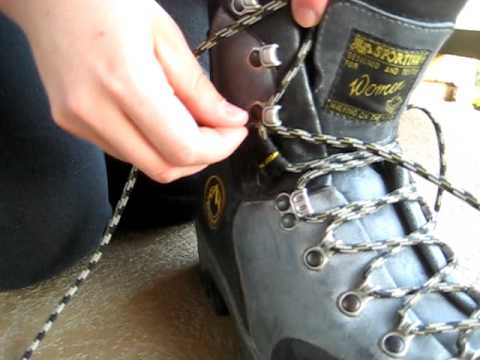
Boot laces: One way to help prevent blisters from forming on your heels, and toes from hitting the front of your boot, is to make sure your boots are properly laced, especially on descents.

When heading downhill it’s important to make sure that your heel doesn’t slip forward, thus causing friction which leads to blisters. The key is to keep your heel secure within the boot, while still allowing some room for natural swelling that occurs in the fore and mid areas of your foot.

Most good hiking boots have two types of eyelets: closed metal rings along the top of the foot, and quick-release types on the top of the boot above the ankle.

On the lower eyelets along the top of the foot, it’s best to lace your shoes with a little give. In other words, not snug, but not real loose either. This will give your foot room to expand as your foot swells during a hike.

Then, on that last lace before you start lacing through the quick release eyelets, do a single, very snug, overhand loop. Lace through the first pair of quick release eyelets and then do another snug overhand loop. Do the same all the way to the top of the eyelets (don’t strangle your ankle though!). This will anchor your heel area to the boot and keep it from sliding.

Another option for lacing boots, especially if you have narrow feet, is to use the technique outlined by the Hiking Lady in this video:


Gaiters: Most people would agree that wet socks suck. Wet socks are not only uncomfortable, but can also be dangerous if it’s cold out. Moreover, hiking for long periods in wet socks is a prescription for blisters.

One way to combat wet terrain, snow, and even sand and pebbles from jumping into your boots, is to wear gaiters. Basically there are two types: high and low. High gaiters are used for snowshoeing and mountaineering, extend to just below your knees, and are designed to keep your socks and pants dry. Short gaiters generally cover the lower part of your shin and are used in warmer weather to protect against wet terrain, sand and pebbles.

Blisters: The following are a few other suggestions for avoiding blisters:

* Train your feet. Don’t go out on a long hike without taking the time to toughen up your feet by doing walks or short hikes leading up to the big day.

* Don’t try to break in brand new boots on a long hike either. Wear a new pair around town, or on short hikes, before taking them long distance.

* Walking barefoot around the house, especially outside, will toughen the skin of your feet.

* Stop and remove dirt, sand, or any other debris that gets in your boots ASAP.

* Air your feet out during a break in order to cool and dry them off.

* For people with feet that sweat excessively, try using extra-strength antiperspirant creams, roll-ons, or powders to reduce sweating.

* If you have areas on your foot that have caused problems in the past, try putting moleskin or athletic tape on before blisters have a chance to form.

* If you do develop a hot spot, cover them immediately with moleskin, athletic tape, Adventure Medical Kits GlacierGel pads, or even duct tape before they become blisters.

Treating Blisters: Well, if all of the above fails, and you still wind up with a blister, here are a few tips for treating them (and another good reason for keeping a small first aid kit in your pack).

* If the blister isn’t torn and is full of liquid, pierce it from the side with a sterile needle at its base and let all the fluid drain out. If the affected skin is still intact, don't remove it. Instead, cover the drained blister with moleskin.

* If the blister is already torn, carefully cut away the loose skin and clean the area with antiseptic. Allow it to dry and harden in the open air for as long possible. Before resuming your hike, put a band-aid or gauze over the torn blister and then put a layer of moleskin over the blister area. It’s best to cut a doughnut shaped piece of moleskin that fits around the blister rather than putting it directly on it.

* If you have a blister that's buried deep in the skin and doesn't hold a lot of liquid, it’s best not to puncture them. Instead, just cover them with a moleskin doughnut to relieve the friction.

If you have any other helpful tips, please feel free to add them in the comments section.


Jeff
HikingintheSmokys.com
Read More

Final Full Moon hike in Cades Cove

Tuesday, August 17, 2010

No comments
Next Tuesday night, August 24th, is the final "Full Moon" hike in Cades Cove of the Great Smoky Mountains for the summer.

This is an excellent opportunity to take a stroll in Cades Cove under a full moon. If interested, meet at the Orientation Shelter near the entrance to the Cades Cove Loop Road. The hike is from from 7:00 PM to 9:00 PM.


Free Shipping over $45 at Altrec Outdoors


Jeff
HikingintheSmokys.com Detailed information on trails in the Smoky Mountains; includes trail descriptions, key features, pictures, video, maps, elevation profiles, news, and more.
Read More

Andrews Bald hike with Trails Forever

Sunday, August 1, 2010

5 comments
Join Christine Hoyer, volunteer coordinator for the Trails Forever program, for a 3.8 round trip hike to Andrews Bald on Saturday, August 28th. Meet at the Clingmans Dome parking area at 9:00 a.m. Wear good hiking boots, and pack water and a light lunch. As always when you're hiking in the mountains, it's a good idea to bring rain gear as well.

Learn about the Trails Forever program and witness firsthand some of the beneficial results of its trail improvement projects. Andrews Bald was one of the first of the park's hiking trails to be improved under this program.

Reservations are required and limited to 20 participants. A fee of $10 per person will be donated to the Trails Forever Endowment. Call 865-436-7318, Ext. 222 or 254 to register by August 25th.

For more information on the trail, please click here.

Read More

Full Moon Hike in Cades Cove

Wednesday, July 21, 2010

3 comments
Next Monday night, July 26th, is the second in a series of "Full Moon" hikes in Cades Cove of the Great Smoky Mountains this summer.

This is an excellent opportunity to take a stroll in Cades Cove under a full moon. If interested, meet at the Orientation Shelter near the entrance to the Cades Cove Loop Road. The hike is from from 8:00 PM to 10:00 PM.


Jeff
HikingintheSmokys.com Detailed information on trails in the Smoky Mountains; includes trail descriptions, key features, pictures, video, maps, elevation profiles, news, and more.
Read More

Photos from the trail

Thursday, June 17, 2010

No comments
Below are several photos from the three trails we hiked during our recent visit to the Great Smoky Mountains.

The footbridge over the Rough Fork of the Cataloochee Creek is located near the Caldwell Fork Trailhead. According to Hiking Great Smoky Mountains by Rodney and Priscilla Albright, it's the longest footbridge in the Great Smoky Mountains:

While hiking the Boogerman Loop we saw three snakes - I nearly stepped on two of them:

Beautiful forest scene on the loop hike:

One of many fire pinks we saw on the Boogerman Loop:

As mentioned in a post last week, we encountered a lot of rain during our hike to Hen Wallow Falls. We were extremely fortunate to have a 15 minute break in the rain just as we arrived at the falls, allowing us to enjoy them and shoot a few pictures:

Lots of green on the Lumber Ridge Trail out of Tremont:

There were a few places along Lumber Ridge that provided views of the surrounding mountains through the trees:

There were also quite a few small azaleas bushes that were in full bloom along the trail as well:


For more information and more details on each of these hikes, please click on the following links:

* Boogerman Loop Hike

* Hen Wallow Falls

* Lumber Ridge Trail


Jeff
HikingintheSmokys.com Detailed information on trails in the Smoky Mountains; includes trail descriptions, key features, pictures, video, maps, elevation profiles, news, and more.
Read More

(Bonus) Hike of the Month: Gregory Bald

Thursday, June 3, 2010

2 comments
Although Gregory Bald is an excellent destination anytime of the year, mid to late June is the absolute best time to make the trek to the summit. In addition to its excellent views into Cades Cove, Gregory Bald provides for one of the best flame azalea shows in the world during this time period.

In fact, azalea lovers from all over the world come here to visit perhaps the finest display of flame azaleas anywhere on the planet. According to the Great Smoky Mountains Natural History Association the various hybrids of azaleas on Gregory Bald are so impressive and unique that the British Museum of Natural History has collected samples of them.

This isn't an easy hike - the trail climbs over 3000 feet, and the roundtrip hike is 11.3 miles - but it's well worth it. As mentioned in a previous post, I would definitely rate this as one of the top 3 hikes in the Smokies.

Here's a preview of some of the sights you'll see at the top:


For more information on this hike, please click here.


Jeff
HikingintheSmokys.com Detailed information on trails in the Smoky Mountains; includes trail descriptions, key features, pictures, video, maps, elevation profiles, news, hiking gear store, and more.
Read More